
 |
| Click Any Photo to View Larger. |

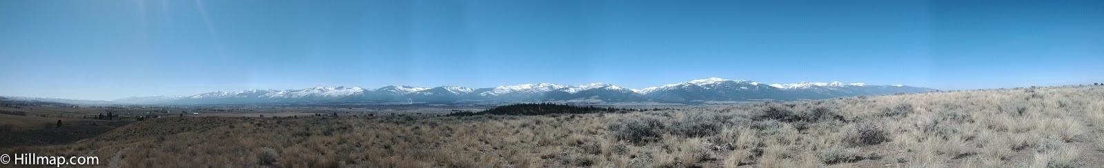
The Bitterroot Valley is a paradise formed by a geological oddity: millions of years ago the Sapphire Mountains slid off the West edge of the Idaho batholith sculpting the steep East face of the Bitterroots and leaving a wide fertile valley. Viewing satellite photos (below) shows the uniqueness of the range.
It is difficult to capture the results in words. From numerous points in the valley one can see the entire 60 mile sweep of the central Bitterroots raising into craggy snow caped peaks unsheltered by foothills. From spots one can catch glimpses of massive granite walls lurking just up one of the steep sided canyons. Watching the weather change in these peaks has become one of my daily pleasures. With 70 degree days in the valley bottom, Spring has arrived but the mountains 5,000 feet above are still locked in winter with hints of storms and fresh snow.
With a recent software update my android phone acquired the ability to take panorama photographs. The results aren't perfect but here are a few attempts to capture the bitterroots as seen from my daily runs along the irrigation ditch that traverses the East side of the valley.

8 comments:
In my opinion, it will be useful for you to read this. It will help students with avoiding plagiarism for sure.
Here https://pro-academic-writers.com/blog/compare-contrast-essay is a great guide on compare and contrast writing!
"Bitterroot Panoramas" enthralls with its moving narrative and breathtaking images. With their exquisite rendering, the magnificent landscapes evoke a strong sense of oneness with the natural world. It's an engaging experience because of how emotionally relevant and relatable the characters' journeys are. An incredibly impressive narrative and artistic fusion that makes a lasting impression.In my opinion, it will be useful.
Cost of Divorce in New York
Catching the outcomes in words is troublesome. From various places in the valley one can see the whole 60 mile clear of the focal Bitterroots raising into rocky snow caped tops unsheltered by lower regions. From spots one can get looks at gigantic stone walls prowling simply up one of the lofty sided gullies. Watching the weather conditions change in these pinnacles has become one of my everyday joys. disorderly conduct in maryland
The Bitterroot Valley sounds like a truly special place, a testament to the power of geological forces. That 60-mile sweep of peaks must be breathtaking! I wonder, what is the most striking change in weather you've witnessed transform those mountains, from valley view? Reminds me of driving my Eggy Car.
Bitterroot Panoramas offers breathtaking views that capture the rugged beauty of the region. The sweeping landscapes, vibrant colors, and serene atmosphere make it a visual delight for nature lovers and photographers alike. Each panorama immerses you in the majesty of Bitterroot, leaving a lasting impression of tranquility and wonder.
Arc fault Breakers buyers in California
Bitterroot panoramas unfold as wide ribbons of mountain and sky, where rugged peaks rise above sweeping valleys. Wildflowers color the foothills, while rivers glint through pine forests. Light shifts gently across the landscape, revealing solitude, clarity, and the timeless calm of Montana’s wild heart in every changing season’s open vista. Sex Crime Attorney
The sweeping landscapes, vibrant colors, and serene atmosphere make it a visual delight for nature lovers and photographers alike. Each panorama immerses you in the majesty of Bitterroot, leaving a lasting impression of tranquility and wonder.
foxy vape
Post a Comment