 |
| The West Mullan Fire from I-90 west of Missoula. |
Wildfire season is in full swing across the American West. You can view updates on various fires on inciniweb, but the maps showing perimeters are a bit small and don't have any map layers beyond the basic google terrain and satellite maps.
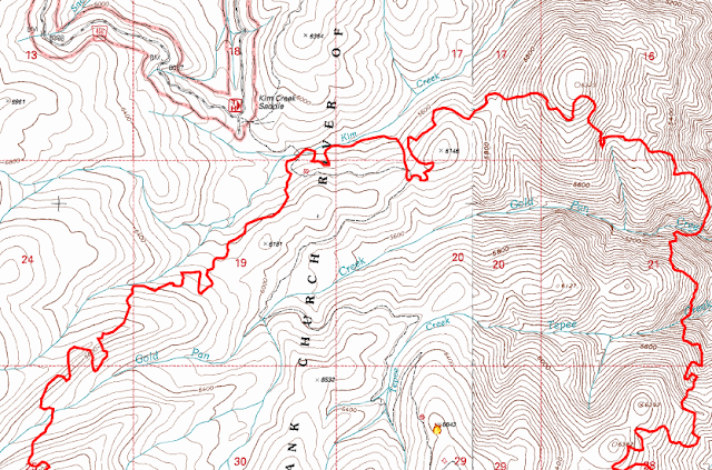
Fortunately, they post daily kml files and there is an easy trick that will let you view these files (or any public kml/kmz file on the web) in hillmap. Once you are in hillmap, you can view the fire perimeter on any topo map layer available on the site. The result looks something like this:
Step 1: Go to Inciniweb and Copy the Kml/Google Earth Address
Find the fire you want to map on inciweb. There is a list of all wildfires on the home page, or you can search by state or incident.
On the inciniweb incident information page for that fire, there is a list of Incident Permiters on the right. They suggest viewing these in Google Earth but we'll copy the Address (or url) to load into hillmap instead. Newer fires may not yet have an incident perimeter online until they have been mapped with a fly over.
On the inciniweb incident information page for that fire, there is a list of Incident Permiters on the right. They suggest viewing these in Google Earth but we'll copy the Address (or url) to load into hillmap instead. Newer fires may not yet have an incident perimeter online until they have been mapped with a fly over.
Right click on the permitter you want and click "Copy Link Address".
Step 2: Go to Hillmap And Open your Browser's JavaScript Console
With a browser window open to hillmap.com you will need to open your browser's javascript console. This can often be found under the "tools" or "developer tools" menu or you can use the keyboard shortcuts listed for various browsers here.
Step 3: Enter this bit of JavaScript
You'll need to enter just a bit of javascript to load the kml layer:
new google.maps.KmlLayer("URL").setMap(l_map)
Where URL is the url you copied in step 1. For example I entered:
new google.maps.KmlLayer("http://rmgsc.cr.usgs.gov/outgoing/GeoMAC/current_year_fire_data/KMLS/MT-BRF-HR1U%20Gold%20Pan%207-26-2013%200216.kml").setMap(l_map)
The only tricky thing is that the url needs to be contained in single (' ') or double (" ") quotes.
Note: to make a printable map you can do steps 2 and 3 on the print page window before you print.
Other Sources of Data
Lots of other agencies post data in kml or kms format. Not all of these will work well in hillmap, but a couple places to start looking are:
For any developers out there the left and right map objects in hillmap are global objects called (creatively) l_map and r_map.
These are standard Google Maps Javascript Api Map objects so you can add Kml Layers to them like we've done here or do anything else allowed for in the Google Maps Javascript Api.
These are standard Google Maps Javascript Api Map objects so you can add Kml Layers to them like we've done here or do anything else allowed for in the Google Maps Javascript Api.
Feel encouraged to play with them and let me know if you come up with something cool!


